 As much as 38% of rural locations in census blocks reported to have broadband available to them may, in reality, lack broadband, according to USTelecom. The organization, which represents broadband providers, undertook a pilot test earlier this year aimed at addressing problems with FCC broadband availability data as depicted on the National Broadband Map. The results of the USTelecom broadband map pilot have now been filed with the FCC.
USTelecom Broadband Map Pilot
USTelecom undertook the broadband map pilot in response to concerns voiced by many parties that the map overestimates broadband availability. The reason is that an entire census block is considered to have broadband even if only one location in the block has service available to it.
Fixing this problem has become increasingly important as policymakers pursue a range of funding programs aimed at making broadband available nationwide.
The USTelecom pilot focused on two states – Missouri and Virginia. For those states, the organization created what it calls a “fabric.” As Jim Stegeman, president & CEO of CostQuest, explained on a webinar about the pilot yesterday, “the fabric helps us understand what’s unserved.” CostQuest specializes in broadband deployment data and is the company that created the cost model that underpins the FCC Connect America Fund program.
As Stegeman explained, the fabric that USTelecom created for Missouri and Virginia started with geocoded locations of homes and businesses. Onto that the company overlaid polygons, also known as “shape files,” showing where service providers offer broadband. That data was collected from service providers participating in the pilot.
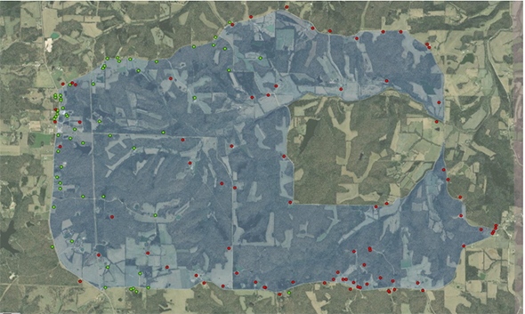
Using all this information, CostQuest and USTelecom were able to create maps showing the exact location of homes and businesses in a census block, with locations color coded to indicate whether broadband is available to them.
The map below shows 10 census blocks, with dots indicating homes and businesses. Locations with green dots have service available from one of the participating service providers, while red dot locations can’t get broadband from any of those providers.
Stegeman noted that the estimate that as much as 38% of rural locations reported to be served are instead unserved may be on the high side because certain cable companies did not participate in the pilot. It’s unfortunate that the results couldn’t be more definitive. But even if the discrepancy is half the maximum estimated size, it’s a cause for concern.
Other key findings from the USTelecom broadband map pilot:
- 48% of rural census block fabric location counts don’t match currently used estimates of location counts
- 23% of rural pilot locations were not geocoded to the correct census blocks
- 61% of current geocoded locations for customer addresses do not correspond with the buildings that would need to be served at those addresses
As USTelecom has previously explained, the latter point is critical to a service provider being able to estimate the cost of bringing service to an unserved location. The provider would need to do to submit an accurate bid in a reverse auction, such as the one envisioned for the proposed Rural Digital Opportunity Fund.
The cost to create a nationwide fabric like the ones created for Missouri and Virginia would be $8.5 to $11 million, USTelecom estimates. Annual updates would cost $3 to $4 million.